The Regional District of Nanaimo has a better understanding of wildfire threats after risk reports were created for rural areas.
Diamond Head Consulting Ltd. analyzed public land in RDN electoral areas last July and August, stated a staff report. The plans examine wildfire risk for areas where development borders forest (wildland-urban interface) and advises on wildfire resilience through principles of FireSmart, a nationwide program.
RDN’s electoral area services committee endorsed the reports at its May 5 meeting.
Cedar, South Wellington, Yellowpoint and Cassidy (Area A)
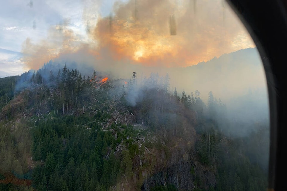
With an area more than 6,000 hectares, the report listed Area A’s overall wildfire risk as moderate and “the potential wildfire behaviour in the landscape is generally moderate, with few forests posing a high threat of wildfire behaviour.”
“High-threat areas driven by slope are found within small areas of Hemer Park, on the shores of Quennell Lake, and in the Nanaimo River and Haslam Creek River valleys,” the report said.
Fuel management was suggested for only one section of Area A, at Kipp Road Community Park near Nanaimo city limits and Area A and C homes. The report said the area has “pockets of high-predicted wildfire threat.”
Water supply differs across the area, according to the report, with most areas, other than in North Cedar Improvement District, lacking fire hydrants or having limited community water supplies sourced from wells. However, there is potential for firefighters to draw water from sources such as Holden and Quennell lakes, the report said.
Gabriola, DeCourcy and Mudge Island (Area B)
Overall wildfire risk for Area B, which measures close to 5,800 hectares, is moderate to high, said the report. While potential wildfire behaviour is characterized as “generally moderate,” there are forests across the area, which present “high or extreme threat of wildfire behaviour.”
Further, there are extensive wildland-urban interface areas, “characterized by … a lack of clear boundaries between forests and homes,” stated the report, with “high potential for severe wildfire to occur” in these areas, presenting threats to life and properties.
An area of concern is 707 Community Park, the report noted, with one section of the park considered high-risk because of proximity to residences. The threat is due to “younger, dense coniferous vegetation.” The RDN permanently banned homeless camping at the park in April due to wildfire risk.
In terms of water supply, most residents use wells complemented with cisterns used to catch rainwater, stated the report. There are cisterns located on the three islands dedicated to emergency water supply. Area firefighters would likely be the first on the scene of a wildfire, stated the report, and B.C. Wildfire Service would respond to fires on the outer islands from its Parksville and Cobble Hill bases.
A fuel management plan is being developed for part of the park, “characterized by high threat [young dense Douglas-fir] fuels upwind of homes in the Gabriola townsite,” said the report, and would reduce risk of fire spreading to the townsite.
Extension, Nanaimo Lakes, East Wellington and Pleasant Valley (Area C)
Area C, measuring close to 110,000 hectares, has “moderate” wildfire risk overall and “generally moderate” potential for wildfire behaviour. Sloped areas of high threat are located at the northeast area of Mount Benson, with steep terrain and continuous slopes, the report noted.
Water supply is limited with secluded hydrants at Extension and South Forks areas and potential water sources for firefighters at Witchcraft, Blind and Harewood lakes, the report added. The potential at the Cranberry Fire Protection District is “more limited” due to shortage of surface water supply.
Managing forest fuel in Area C is “somewhat limited,” based factors including limited amount of public land, said the report, but land near East Wellington and Galloway Gulch, on Crown land and Vancouver Island University woodlot licence, has “high-moderate” threat and thinning of areas of higher density conifers could reduce risk, the report said.
RDN applied to the Union of B.C. Municipalities’ community resiliency investment program for grant money for the reports in February 2021.
Catherine Morrison, RDN manager of emergency services, said staff will review plans and engage with fire departments and partners, when asked about next steps at the meeting. Grant funding opportunities through the program will be explored and recommended priorities will be reviewed and incorporated into the 2023-27 financial plan, she said.
For reports on all RDN electoral areas, visit https://rdn-pub.escribemeetings.com.
READ ALSO: Permanent homeless camping ban recommended for Area B park
READ ALSO: Crews battle wildfire near Ladysmith
reporter@nanaimobulletin.com
Like us on Facebook and follow us on Twitter