Paddling enthusiasts are celebrating the grand opening of what could one day become the world's longest marine trail network.
After three years of planning – the original idea emerged almost 20 years ago but ultimately fizzled out – between the BC Marine Trails Network Association and the provincial government, two large sections of marine trail linking Nanaimo and Victoria will officially open during annual Vancouver Island Paddlefest celebrations in Ladysmith on May 14.
"It's not big, it's huge," said Stephanie Meinke, president of the association and Nanaimo Paddlers member. "It's way bigger than I ever imagined it would be. One of the challenges was we didn't really know how to do it at first. We knew what we wanted, we had the vision, but we didn't know how to go about creating it."
Officially, the Gulf Islands Marine Trails Network and West Coast Vancouver Island North Marine Trails portions of the network will open as predecessors to a much bigger network along the B.C. coast. Nanaimo's access points include Brechin Boat Ramp and Cedar-By-The-Sea.
Over time, organizers, including nine Island paddling organizations, will attempt to connect the trail from the northernmost coastline near Alaska to the Washington State border. At its completion, the marine trail network will be the longest water trail on the planet, attracting paddlers from B.C., the rest of Canada, U.S.A. and around the world.
"Previously there was nothing on record saying these places were important kayaking sites. Fish farms, resorts or industry could move in and the site would no longer be there for paddlers," said John Kimantas, author of The Wild Coast guide book series and one of nine task force members.
"This protects these areas forever with official status. The big wakeup call for the paddling community was the Maa-nulth Treaty ... which turned a lot of recreational areas into private property and kayakers took note of this."
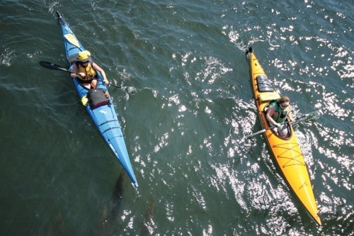
The trail network is an interconnecting series of access and launch sites and campsites for users of small, beachable watercraft, mostly hand-powered such as kayaks, canoes and outrigger canoes.
The distance between essential sites will average about 16 kilometres while alternate sites will give paddlers further options during their adventures. Most sites will be located on Crown lands in provincial, national or regional parks, and won't have any amenities other than natural splendour for paddlers to enjoy.
Meinke added that B.C.'s coast is already an international destination for paddlers because of it's accessibility, rugged beauty and routes for all abilities, but completing the project in its entirety will take years.
"We've just scratched the surface of the size this endeavour. We still have to do the rest of Vancouver Island, all the islands in between Vancouver Island and the mainland, the Lower Mainland, the central coast and the north coast and Haida Gwaii. That's a lot."
Sites will be selected based on scenic beauty, refuge from inclement weather, accessibility during low and high tides and suitable land for camping.
The original concept of a marine trail in B.C. emerged in the early 1990s when Peter McGee, author of Kayak Routes of the Pacific Northwest Coast, recognized a growing need to facilitate such a route.
Though interest was strong to start, it waned over time. McGee and others, however, kept all of their work and records until late 2007 when increasing pressures on popular sites caused paddling enthusiasts to once again took hold of the idea.
"This will be very cool for Vancouver Island as a whole," said Kimantas. "It underscores the fact that this is one of the main kayaking areas in the world and the tourism potential is unreal."
reporter2@nanaimobulletin.com