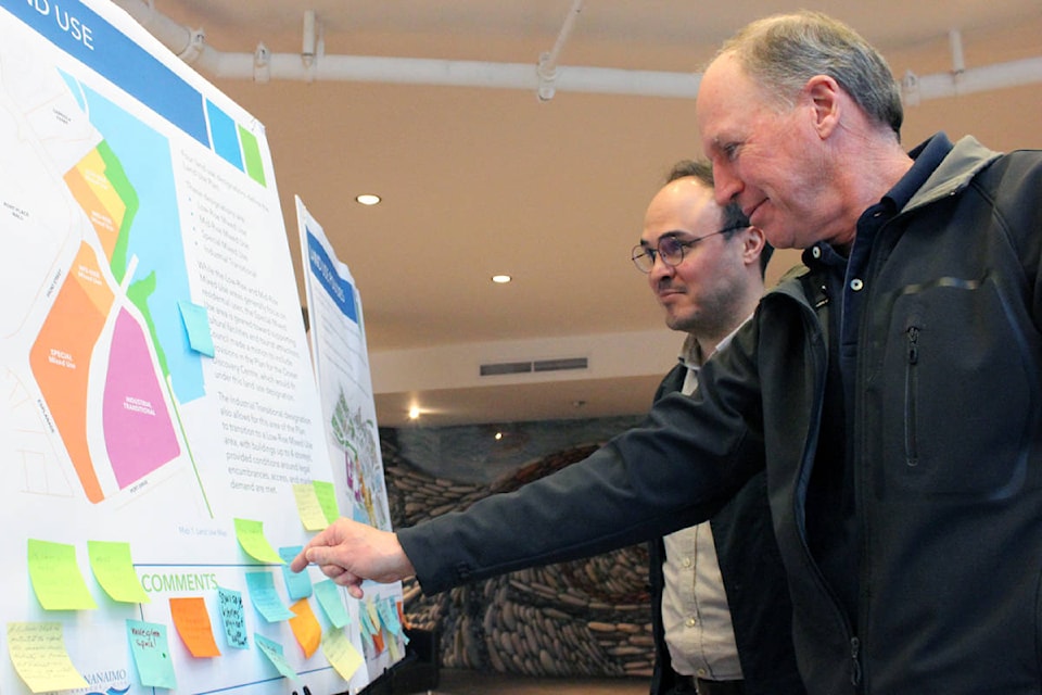
Building height, density and green space. Those were just some of the comments the City of Nanaimo received during their Port Drive waterfront master plan open house on Wednesday night.
Karin Kronstal, social planner with the city, said around 140 people attended the open house, which was held in the lobby of the Vancouver Island Conference Centre. She said most of those who showed up to the open house were excited about the Port Drive waterfront master plan.
“I heard a lot of enthusiasm from people about seeing the development of the south downtown waterfront,” she said.
Endorsed by councillors in January, the waterfront master plan proposes a range of uses for undeveloped city-owned land along Front Street, Port Drive and Esplanade. It calls for a mixed-used precinct along Front Street, a residential precinct located closer to the water and a industrial precinct that would be located on the east side of the railway. The mixed-used and residential precincts incorporate low- and mid-rise buildings. A public walkway, a proposed Ocean Discovery Centre and a boat ramp are also included in the plans.
Wednesday’s open house follows up an open house held last June.
- RELATED: Nanaimo councillor says Port Drive ready for development
- RELATED: City of Nanaimo seeks public input on waterfront plan
- RELATED: Nanaimo residents share views on future of waterfront property
- RELATED: Proposed Ocean Discovery Centre receives endorsement from city council
- RELATED: Protection Island residents float boat ramp idea for south downtown waterfront
- RELATED: Nanaimo city council endorses south downtown waterfront draft plan
Kronstal said the comments she received were around height and density within the residential and mixed-use precincts.
“Some people wanted to keep it all low-rise or low- to mid-rise, but I think what we were trying to achieve here was a balance between buildings that step down and don’t block views and enough density to help our struggling housing market and to make it financially viable for anybody to build,” she said.
Kronstal said she also heard a lot of people indicate that it was very important for the city to ensure the south downtown waterfront doesn’t remain an empty space.
“In terms of mixed-use, people really want to see an active and vibrant waterfront with coffee shops and retail spaces,” she said. “They don’t want to see a dead zone around the waterfront, they want to see places they can go and enjoy with their family and friends.”
Miko Betanzo, a community planning professor at Vancouver Island University who was hired by the city as a consultant on the project, said some of the comments he heard were around the rationale for including an industrial precinct into the plan. He said while the city would prefer other designations for the industrial area, there isn’t much choice at the moment.
“The city purchased the property in 2010 and when they purchased it, it came with a bunch of legal encumbrances on it. They are leases basically, and the leases are owned by Southern Rail, Seaspan, CP Rail and others,” Betanzo said. “Those encumbrances exist over this property and they are basically like perpetual rights of way.”
Betanzo explained that the industrial precinct is home to the only barge-to-rail bridge on the Island. He said the city intends to transition that area to likely mixed-use over time, but that it must remain light rail to allow Seaspan and others to continue operating,
“This is kind of foreseen as being light industrial but obviously allowing it to transition into mixed-used,” he said. “About five years ago the South Downtown Waterfront Initiative showed a plan that utilized all these lands to their highest and best potential and that is kind of the overall vision, but for right now this is foreseen for the next 10 to 15 years.”
Betanzo said another consideration for city planners going forward is First Nations land rights and claims, adding that planners need to work with the Snuneymuxw throughout the entire process.
“There have been areas that have been left sort of untouched in terms of showing development on them, knowing that those are areas where there are artifacts that have been found and are registered with the archeological registry and so it still very much an issue that is going to inform where this plan goes,” he said.