Nanaimo Port Authority is plugging B.C. coastal communities into a navigation system that enhances safety and security and cuts operational costs to make ports more competitive.
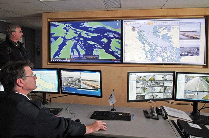
Rodney Grounds, Nanaimo Port Authority manager of marine operations, points a cursor at a computer image of B.C. Ferries’ MV Coastal Renaissance approaching Nanaimo Harbour. A mouse click commands a computer to ping the ship’s automatic identification system (AIS) transponder – the marine version of the aviation industry’s identification friend-or-foe system – which pops up the ferry’s identity, speed, draft, position and a raft of other telemetry – on one of two wall-sized flat screens.
The mouse click simultaneously swings a camera onto the ship, still 6.5 kilometres away. Grounds zooms in on the upper car deck where a deckhand reaches for an intercom handset to receive orders from the bridge, seen on the second screen.
“He should be slowing down soon,” said Ed Dahlgren, port authority director of operations and harbour master and former ferry captain, noting the ship’s position.
Virtually every ship in the Salish Sea, from Campbell River to the coast of Washington State’s Olympic Peninsula, including the ports of Nanaimo, Victoria and Vancouver, is now tracked by radar, underwater acoustic wave and current sensors, GPS, video surveillance – in visual and infrared spectra – and AIS. That data streams to computers in a building near the Nanaimo Assembly Wharf that has become the nerve centre for the B.C. Marine Electronic Highway, a joint project developed by Nanaimo Port Authority and Vancouver-based Xanatos Marine, developer of the Marine Domain Awareness system.
“We have four receiving stations at this time,” Grounds said. “One in Campbell River, one in Nanaimo, one in Saanich, one in Vancouver Harbour.”
With another mouse click the camera image is swapped for a 3-D rendering of the Salish Sea with symbols of shipping traffic lanes and ships depicted in green, yellow and red, depending on their cargo and other factors. The system provides data in real-time.
 “Ours is real-time accurate enough to use for accident investigation because it is the real track of the vessel,” Dahlgren said. “Then you can take the meteorological information of the story and do a second-by-second cross-reference so you have the real external parameters affecting the vessel during the prosecution of its voyage.”
Grounds plays back data stored from an accident in Vancouver Harbour in 2015 when a tugboat sank while berthing a cargo ship. The monitor shows craft responding, plus data on wind, currents and ship movements before the sinking. Such information can help investigators explain how and why accidents happen. Detailed information on current speeds at various depths, plus wind and wave action can also help port operators decide whether, say, two or four tugs will be needed to escort large craft into port, which can translate into huge fuel and cost savings. Ports with this capability are attractive to shipping operators under pressure to cut costs.
There are side benefits on land, too. The system’s cameras can spot vandalism and theft in port facilities and plot oil and garbage spills. Their infrared capability can spot a possible fire in a shipping container, detect the heat signature of a person in the water or plot GPS coordinates of a heat plume, which can be sent directly to the positioning system in the cab of a firetruck, directing the crew to the source.
“We used this to be able to cut through smoke and actually assisted Nanaimo Fire Rescue in some small fires that they had last summer,” Grounds said.
The Marine Domain Awareness system continues to be expanded and will eventually include all of the B.C. south coast including the strait of Juan de Fuca.
To learn more, please visit http://deepsea.npa.ca.
photos@nanaimobulletin.com