Katelyn Merrett can tell you what it's like to pedal a 180-kilogram tricycle up the Nanaimo Parkway Trail.
Just 100 metres into her task last week, the Google map special collections officer hit her first steep hill. It took eight attempts, by alternately standing on the pedals with her full weight to crank them a few centimetres, stop, hold the brake and then crank the pedals a few more centimetres to get one full rotation out of her wheels.
"I was wondering when that hill was going to end," Merrett said.
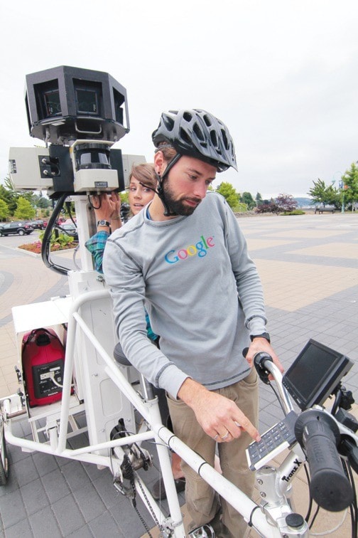
Merrett and co-worker Rob Campbell from Google Maps are putting plenty of sweat and toil into mapping and photographing Nanaimo's Parks and trails on the company's Street View tricycle.
The trike carries a computer, GPS system, cameras and other devices with electricity provided by a small on-board gas-powered generator, to gather data and images. The bike enables Google to get into areas motorized vehicles can't.
The pair are mapping most of Nanaimo's major parks and had already run through Bowen, Neck Point, Colliery Dam, Jacks and Biggs Point, Pipers Lagoon and Beban parks, plus the E&N and Parkway trails by Wednesday, when they mapped Maffeo Sutton Park. They will also map the trails of Nanaimo's waterfront, Westwood Lake Park and other areas suggested by the city.
"We don't just do park systems," Merrett said. "In other cities they focus on other tourist hot spots like university campuses, zoos, theme parks, golf courses – anything that's inaccessible by a vehicle that could be of use to the public."
How long the work will take depends on the weather and the terrain.
Campbell and Merrett have been mapping urban trails across western Canada since May. A second trike and crew are mapping trails in the eastern half of the country.
The data will ultimately be processed and available on Google Maps, but it could take a year of processing before the information becomes public.
The city has fostered a good working relationship with Google.
Google Earth's chief technology officer named Nanaimo the Capital of Google Earth, said Guillermo Ferrero, city manager of business applications.
"Residents will have an opportunity now to see what the trails look like, before they go out for a bike ride," Ferrero said. "New businesses or people relocating to Nanaimo may want to go to Street View and look around the houses they want to buy. It benefits the residents, it benefits business and the tourism community as well."