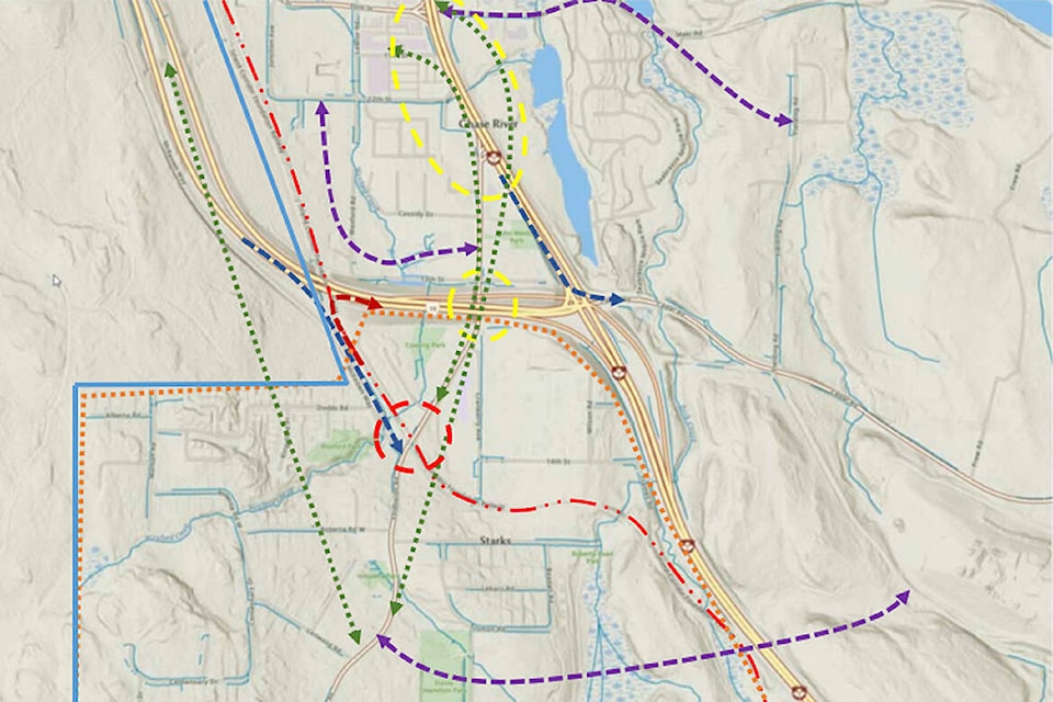
Nanaimo city staff, council and residents continue to question whether there are better ways to move traffic in and out of Chase River, Cinnabar Valley and Extension.
At a governance and priorities committee meeting Monday, Nov. 8, staff presented a report on the work needed and potential costs to study how to alleviate traffic congestion on the Cranberry Avenue, Extension Road and Trans-Canada Highway corridor which has been the only direct link to Nanaimo since residential development started in the area in 1970.
The information report was a result of a motion put forward earlier this fall by councillors Sheryl Armstrong and Tyler Brown to determine the cost and scope of work needed to create a Chase River and Cinnabar Valley mobility plan that considers automobile, pedestrian, public transit, cycling and other accessible transportation modes.
Jamie Rose, city transportation manager, said in his presentation that development in the area has continued following a 1970s and ‘80s model. There are about 1,300 homes and counting in the area and residents currently must navigate a traffic bottleneck of intersections at the Trans-Canada Highway to access services, jobs and schools in and beyond Nanaimo.
“This particular neighbourhood started transitioning from green field agricultural to single-family residential in the ‘70s, about 50 years ago … There are not a whole lot of daily services or service providers in the community. There’s little to no employment or retail, grocery or medical services,” Rose said. “This combination of land use and road system require everybody to enter the community and exit the community for all of their daily activities, which creates a focal point of traffic loading on the Cranberry, Extension, Trans-Canada Highway system of roads and intersections.”
READ ALSO: City to explore ways to ease congestion and improve road safety in south Nanaimo
Rose said during peak periods the highway intersections at Cranberry Avenue, Maki Road, Tenth Avenue and Cedar Road suffer from “over demand” and “under capacity.” The city and B.C. Ministry of Transportation and Infrastructure share responsibility for the intersections.
“Anybody entering or exiting that neighbourhood needs to go through this sequence of intersections,” Rose said. “This particular area may not have the highest collision rate, but whenever there is a collision, the entire community has to experience it and so it is a particular frustration to them.”
Adding connecting routes to the area to bypass those intersection is complicated by city boundaries, environmentally sensitive and natural features such as Wexford Creek, a railway right-of-way, private properties and other impediments.
Potential options to divert traffic include a proposed ‘Cranberry Connector’ linking Tenth Avenue to Cranberry Avenue, a connection to Maki Road from Cedar Road via Fielding Road, and an off-ramp from the Nanaimo Parkway to McKeown Way that links to Extension Road.
About 10,000 to 12,000 vehicles pass through the corridor daily and future development will likely increase vehicle traffic by 50 to 60 per cent.
“In order for that corridor to accommodate that growth, it will require a great deal of enhancement to increase capacity or another potential solution which we haven’t come across yet,” Rose said.
Coun. Sheryl Armstrong asked if any engineering reports done for the area over the past 30 years point to a possible solution and Rose said additional connection routes built into the area would help to create needed “redundancy.”
“We can continue to build a bigger pipe, but that bigger pipe is going to continue to reach capacity and so the more secondary routes and connection points that we can create, the less burden we put on any one of them,” Rose said.
Coun. Ian Thorpe asked if the B.C. Ministry of Transportation was collaborating with the city on the problem and if there was any “time frame of dealing with this issue before it gets out of control.”
Rose said the ministry has been working with the city since late 2017.
“We have been discussing what options are available and, to be quite frank, the redundancy ones typically carry big price tags,” Rose said. “We have a lot of challenges to overcome to create more connectivity to this neighbourhood.”
Rose noted that potential changes to land use resulting from the proposed Sandstone development in Cinnabar Valley and Cedar could affect traffic volumes and transportation solutions, which was also delaying ministry decisions.
READ ALSO: City reviewing plans for huge Sandstone project in south Nanaimo
“There’s a lot of things that are moving here,” Rose said.
Once some basic questions, such as land use relative to Sandstone, are firmed up then staff can proceed with a mobility study which will involve extensive consultation with area residents and require about 1,200 hours of staff time over three years at a an estimated cost of about $350,000.
“At the end of the day we have some big questions,” Rose said. “We need to determine land use. We need to make a determination on what the community’s aspirations for mobility and connectivity are and then come up with an investment plan to meet those goals and create the community we want.”
photos@nanaimobulletin.com
Like us on Facebook and follow us on Twitter